


Customizable Drone & Remote Sensing Services
Focused on collecting quantitative atmospheric data for rapid digitalization & visualization for environmental impact assessments
Atmospheric Analytical Services trains and manages a professional team of remote pilots to compliment and support multiple data collection projects simultaneously. We are currently consolidating our efforts in Hawai'i where the ongoing Kilauea eruption is taking place...

Our service offers complete and total simplification of environmental monitoring tasks. We provide complimentary services for corporations seeking to reduce their environmental impact, universities, scientific institutions and volcanic observatories supporting their efforts for complex research and investigative projects. We have completed several sophisticated investigations using drones for hazard mitigation and public safety applications around active eruptions in Iceland and degassing volcanoes in Costa Rica. If you feel our systems and remote pilots can complement your research or facilitate your company's environmental impact analysis, please let us know.


_edited_edi.jpg)


We are a professional team of FAA certified licensed and insured remote pilots, project managers, environmental scientists and sustainability consultants. We are prepared to assist your special project with our drone systems and remote sensors. Contact us today to discuss your specific project requirements.
Our team is dedicated to helping you better understand the environmental impacts of doing business. We pride ourselves in leveraging our extensive knowledge base and experience in the field, we can customize our services to fit your project's scope, budget, and timeline. With us, you can trust that your environmental data collection and visualization needs will be addressed accurately, comprehensively and efficiently.


Aerial perspective of the Vatnajökull Glacier, the largest ice cap in Europe covering about 8,100 square kilometers of Icelandic territory, consisting of around 3,300 cubic kilometers of mass.


We understand that every client and project is unique, we treat every customer as if they were our only customer. We are dedicated to providing tailored solutions that perfectly align with your specific requirements. Our team of remote pilots, project managers, scientific advisors will work closely with you to understand your goals, challenges, and desired outcomes.

Atmospheric Analytical Services offers a complete and customizable drone service designed to meet specific environmental data collection and visualization needs. We provide reliable real-time extreme environmental data collection services known for accuracy and precision. Our focus is monitoring and modelling for climate change mitigation.
Renewable Energy Case Study in Hawai'i
The design of the research project was built to support multiple fields in an interdisciplinary fashion; hopefully influencing environmental awareness and positively impacting society while also simultaneously facilitating circular economic development in the renewable energy industry. Hawai’i continues to stand out as a unique island setting where scientists and energy professionals seek a balanced clean energy strategy to provide affordable electricity to everyone. This economic pre-feasibility assessment case study was created to help determine the ideal strategy for the State of Hawai’i, the National Renewable Energy Laboratory NREL, and the Department of Energy DOE explore economically sound solutions to continue with the implementation of the 100% Renewable Portfolio Standard by 2050.
2023 Litli-Hrútur Eruption, Iceland
Fagradalsfjall Volcanic Region
When the 2023 Litli-Hrútur eruption started in the Fagradalsfjall volcanic area in southwest Iceland; Atmospheric Analytical Services LLC was there to complement survey efforts dedicated to monitoring the volcanic region as people began to visit the eruption site. We worked with a team of local professionals and four groups of international researchers from various universities. Our contribution of measuring inhalable particulate matter PM 2.5 and mapping the air quality around the public congregation areas was used for public safety and hazard mitigation during the eruption period. Our systems were also used to measure the volcanic trace gases in the gas plume.
Río Celeste Waterfall, Costa Rica
Tenorio Volcano National Park
This video project was for the University of South Florida College of Global Sustainability as a project proposal for the course on the implementation of the United Nations Sustainable Development Goals. The study abroad project proposal was created to facilitate the advancement of the UN SDG #7 to ensure affordable and reliable renewable energy for all, and SDG #13 combating and mitigating against the negative compounding consequences of climate changes. The United Nations Sustainable Development Goals represent the collective 2030 agenda, and our shared objective on a global scale. The Río Celeste Waterfall inside the Tenorio Volcano National Park in Costa Rica is a wonderful example of natural based solutions and climate change awareness.
Value Proposition - Environmental Management and Energy Security
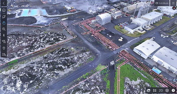
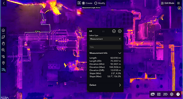
As a FAA certified federal contractor and recognized "Unique Entity" our team focuses Small Business Innovative Research SBIR/STTR projects with USF Connect in Tampa Florida. We specialize in pattern recognition of the quickly changing areas where assets can be effectively managed through rapid aerial inspection via photogrammetry. As geographers and architectural designers begin implementing these emerging technologies such as UAS photogrammetry, Ai DB utilization for smart materials in construction/development and the rendering of digital models capable of showcasing large photogrammetry image data sets via Zip.file that can be interpreted by a variety of stakeholders.
Smart city architectural designers can leverage UAS photogrammetry techniques to create theoretical visuals of their next projects; and use these data sets for multi-application pattern recognition, construction inventory, sustainability of structure, guarantee LEED rating standards according to the U.S. Green Building Council. This type of visualization quickly showcases trends that can eventually move into statistical probabilities facilitating a serious risk reduction strategy to a variety of industries.
In Honolulu, where sustainability in the island setting is a state priority our efforts are streamlined toward environmental management and data support systems. Sustainable development, tourism and construction site performance stand out for several key reasons; inventory management, work-flow optimization, and data communication to investors/stakeholders for accurate quarterly updates.
Construction firms that leverage site digitalization quickly realize the time savings/management benefits that come from this strategy. Rapid data visualization of site performance, either monthly, quarterly, semi-annually or annually normally translates to increased trust between investors-designers/architects-construction firms and often facilitate the collective performance of the P3 in renewable energy infrastructure projects streamlining the profitability/net proceeds coming from the project.
