


3-D Mapping and Digital Modeling
3-D Modeling for Geographic Information Systems
Digital Modeling and Mapping Services - Provide a fast and reliable way to track changes and monitor situational progress for complex projects. We can monitor construction development in cities from real estate to roadway construction. We can survey natural disaster damage such as hurricane flooding in Florida, and provide our clients an interactive 3-D model of the community as well as detailed damage reports with survey grade dependability at 3cm accuracy. Drone surveys of natural disaster damage such as county wide flooding from the Category 4 Hurricane Irma in 2017 or the Category 5 Hurricane Ian in September 2022 offers flood insurance providers quick and accurate ways to survey grade data and map the damage. Our UAS services can track geomorphological changes in natural settings such as degassing in volcanic regions in Costa Rica or environmental degradation and erosion around natural freshwater springs in Florida.
Our UAS digital modeling services help universities and companies visualize the project and optimize decision making for environmental sustainability with innovative solutions such as an aerial photogrammetry and georeferenced digital models support our service portfolio. Our partners at Nira are collaborative entrepreneurs building a visualization platform capable of rendering massive 3-D data sets into georeferenced digital models for real time for interactive, web-based inspection of various extreme environments. The models can then be reviewed on any device, including smartphones and tablets. With the photogrammetry service various industries are able to leverage the full potential of data, quickly visualize large complex environments and situations and then swiftly transforming raw data into valuable insights through visualization.


Active West Crater of the Turrialba Volcano National Park Costa Rica
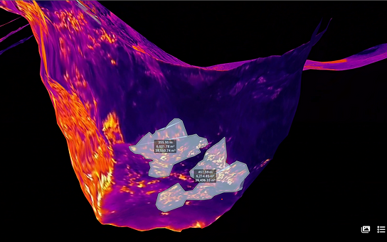
Generating the Digital Model to Measure Size of Degassing Fumaroles Inside Active Volcano Crater


Interactive Digital Model for Monitoring Geomorphology of Fumaroles Associated with Volcanic Degassing

Drone System Used to Enter the Active Crater and Document Fumaroles and Volcanic Degassing


.png)


