Thermal Inspection
UAS Thermal Infrared Inspection
.jpg)
Svartsengi Geothermal Powerplant - Grindavik Iceland

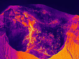
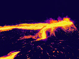
Unmanned Aerial Systems with infrared cameras allow remote pilots to access the most difficult and dangerous locations, collect required data without additional equipment and labor costs. By using UAS IR inspection services, workers don't need gas masks, insurances and companies no longer have to place employees in dangerous areas. Industrial plants, degassing volcanic craters and solar farms can all be surveyed with our IR UAS services. Keep industrial workers safe by using our thermal UAS service to gather the data required for fast and accurate decision making. Increase workflow and reduce risk associated with dangerous working environments. Today drones are being successfully used in hazard assessment and making valued contributions to the scientific community such as the creation of the thermal 3-D digital model of the Turrialba Volcano National Park in Costa Rica. Drones were used in Costa Rica during the month of May of 2023 to assist Universidad Nacional with gathering data on the active West Crater of the Turrialba Volcano National Park. The objective for using UAS at the summit of the Turrialba volcano were to generate crater depth measurements, collect images used with georeferencing software to measure crater radios. UAS with IR sensors were used to monitor the distribution of thermal energy release inside and around the active West Crater.
Coopeagropal R.L. Palm Oil Production Facility Costa Rica
Thermal Inspection of Palm Oil Plant for Preventative Maintenance


Turrialba Volcano National Park Costa Rica
Thermal Inspection to Digital Model of Extreme Environment


Drone Image of Turrialba Volcano

Digitalized Model of Turrialba Volcano
UAS allows for collection of accurate images which keep the researchers and remote pilots safe and out of the danger zone. UAS assists with the rapid accumulation of data, they can be pre- programmed for a specific type of UAS flight mission designed for a certain objective of gathering images for complex terrain or topography. The system can be used around active volcano craters, it can monitor mountains and cliffs subject to cracking, erosion and rock falls. Different extreme and complex environments can be documented and digitalized using this same method such as glacier zones and other sophisticated regions with difficult to access areas.


_edited_edited_edite.png)


